
This is the second of a two-part post.
Before 1911, people travelling east-west above the northern limits of the city chose Davenport Road over St. Clair as their route. A concession line, on the map St. Clair seemed to offer a clean, straight movement through the countryside. On the ground it was a different reality, the ravines that crossed it combined with its un-surfaced condition made it a highly unpopular thoroughfare.

Everything changed when it was chosen as the route for a new streetcar service for north west suburban residents. St. Clair, which as the map indicated, had the makings of an important crosstown street, would be widened beyond the standard 66 to 100 feet. A series of assessment photographs during the road widening captured the range of dwellings, patches of forest and small-scale farms that characterized St. Clair from Avenue Road to Caledonia.

The creation of a streetcar line, at a point in history when very few owned cars, was a momentous development. It heralded a district’s move from marginal and struggling to connected and prosperous. Toronto streetcar historian Louis H. Purley in The Toronto Trolley Car Story 1921-1961 uses the classic device of the “before and after” photographs to drive home the point in 1961.

![]()

Having taken two years to build, the three mile long track opened on August 25, 1913. Pursley wrote that the line was unique in Toronto because it was built on a ‘private way’ in the centre of the wide span of road:’The double track line was laid with a “T” rail in gravel ballast, surfaced with crushed rock.’ This raised track median or “boulevard” as it was called, gave St. Clair instant elegance and an air of expectation of great things to come.
 Not to be upstaged in his own neighbourhood, Sir Henry Pellat installed his own mini-boulevard leading to his home, Casa Loma.
Designed less as an aesthetic statement than as a means of guaranteeing unimpeded travel for its streetcars, the Civic Railway boulevard along with all of its holdings became property of the Toronto Transit Commission in 1921. The details of the wide median are visible below where one can see that stops were marked by a white pole and a paved area served as a platform for passengers.

The raised boulevard was put to good use by camera men as they covered the 1922 funeral of Thomas Craig Eaton in front of the Timothy Eaton Memorial Church.

By 1927 it was necessary to upgrade the tracks. The work began with the lifting of the pavement and curb that formed the boulevard. Through two series of Department of Public Works photographs, documenting first the broken up curbs and platforms and then the construction of the new tracks, the St. Clair streetscape of the 1920’s is revealed.


The question of how to update the design of the built area around the tracks sparked a heated debate. To understand the conflict we can look at the character of St. Clair from the evidence of the photos.
 St. Clair was a busy crosstown transportation corridor with gas stations serving the many vehicles that traveled through it.


It was also an entertainment district with many theatres and small eateries. Hardware grocery and other essential shops catered to the growing neighbourhoods.
In May of 1928 City Council authorized the elimination of the boulevard through lowering the tracks and and merging the pavement on each side of the tracks with the road. This increased opportunity for motorists to cross the tracks but reduced the protection to streetcar passengers making their way on foot between the tracks and the sidewalk.
The possibility of installing cement “safety islands” to protect streetcar riders from the sea of traffic around the tracks was addressed in Council.
The Globe September 26, 1928 p. 17
“Safety ‘Islands’ St. Clair Avenue, To Be Investigated, Committee Named After Hubbub in Control Board Meeting”
…The whole hubbub arose from the early decision of the board not to place safety zones on St. Clair Avenue, a decision later altered.
St. Clair Avenue boulevard is going to be taken up to give the motorists more room. The Mayor wanted safety zones, while Controller Wemp and Hacker did not. The Mayor pointed out that motorists would run past and sometimes into people that had just got off cars. But if safety zones were erected motorists would hesitate to charge into street car passengers, knowing well the severe penalties such recklessness would involve. …
Harris Opposed
But City Engineer Powell stated that Works Commissioner Harris was opposed to such a scheme, and that this evidently helped influence the two Controllers. A tie vote thwarted the motion, and the Mayor stuck the platform plans in his pocket.
Argument Foreseen… the St. Clair Avenue projected safety “islands” may prove matters of considerable contention, both around City Hall and elsewhere.
The Globe October 2, 1928 p. 14
SAFETY ZONES APPROVED
…Controller Robbins called for immediate action so that frost might not interfere with the work. … Mayor: ” It is immaterial who has the glory, as long as the work is done. “(Hear, hear cried some.)
Alderman Pearce—Things are getting to the stage when every consideration is being given to the motor car driver and very little to the street car user. …
Finally the Council unanimously decided to leave the matter in the hands of the Works Committee that body in turn, to report quickly to City Council. A special meeting will be called, if necessary, to deal with the matter expeditiously.

The photo above and those below, taken in the last months of 1928, show freshly installed safety islands that also seem to feature a lantern and white-painted barrier to increase their visibility.


![]()
The St. Clair Avenue boulevard removal and erection of “safety zones” in 1928 triggered a debate on the relative rights of motorists and streetcar users/pedestrians. It foreshadowed the arguments around the Saint Clair right of way many decades later.
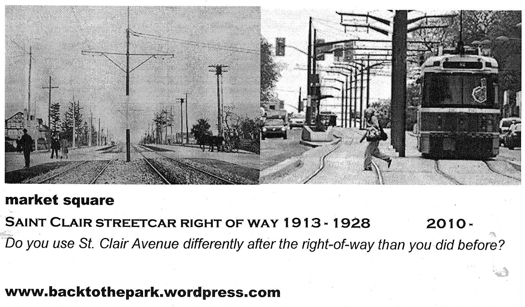

Do you use St. Clair differently after the right-of-way than before?
It’s good to see more quality shops opening.
I j-walk more but you have to be careful.
In a car, getting to the opposite side of the street is very difficult.
I cross St. Clair mid-block more (so patronize businesses on both sides of the street) because ROW creates a safe island. (Just keep eyes open for streetcars!)
I use the streetcar much more often because it’s so much faster.
I take the streetcar more often because it works better.
The traffic has been pushed down to Davenport and Dupont where there’s serious congestion.
I use the on-off feature to go to shopping farther away on St. Clair. I also do more shopping near my home because I buy things on my way back from work.
I walk down my street and then take the streetcar to the subway. I used to walk to the subway.
I’m worried by the number of empty stores.
ROW made transit faster, bad maintenance of system has slowed it down again!
I ride my bicycle on the sidewalk now.
Side street parking has increased. More parking close to businesses needed.
Fewer left turns means more gas used, more delay, worse traffic.
Still divided. (ha ha ha)
Transit is much better. I eat out out on St. Clair more now.
I’m concerned about the empty stores.
I spend more time on St.Clair now, the shade trees make it more comfortable in the summer.
I moved here for the streetcar & love the small restaurants and shops along the street!
I use the streetcar more now.
It’s safer for j-walking (even though it shouldn’t be done)
Traffic moves better over-all.
Interested in how the life of Toronto streets has been captured historically in photography? Check out the exhibition “life on the grid” at the City of Toronto Archives.

Further Reading
the Torontoist “Behold the St. Clair Disaster”
